Metroride
 | |
| General | |
|---|---|
| Map Name | metroride |
| BSP Name | infra_c6_m3_metroride |
| Stalburg Map | metroride |
| Statistics | |
| Photo Spots | 12 |
| Corruption Spots | 0 |
| Repair Spots | 0 |
| Mistake Spots | 0 |
| Geocaches | 0 |
| Water Flow Meters | 0 |
| Connected Maps | |
| Previous Map | metro |
| Next Map | waterplant |
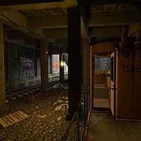
A segment of the Ampstrand Line in the Stalburg transit system. A short, linear map that makes uses of the maintenance tram to show off Stalburg's subway. This map can be considered an action sequence by the loosest definition as there is no imminent danger, but the time window to photograph things is limited.
Story
During the Public Transport Workers Union strike, the metro system was out of service. Mark utilizes a maintenance tram from the Pitheath Station to get to the office. The tram passes through Stenhill and Cupper Park Station, and Mark optionally photographs the various structural instabilities of the tunnels. After some time, the ceiling of a tunnel crumbles, and the floor gives away, causing Mark and his tram to crash through and land in a section of Bergmann tunnels below. Trapped underground yet again, Mark wanders the area to look for an exit.
Locations
Metro Tunnels
The metro tunnels are the tunnels that Stalburg relies on for mass transit. The top level of tunnels, the ones commuters will see, are in poor repair. Various steam pipes are leaking, and some walls are crumbling. Parts of the tunnels are built upon other far older collapsed tunnels, with minimal support below the ground (as witnessed firsthand by Mark).